-
WHAT ARE LONGITUDES?
WHAT ARE LONGITUDES?
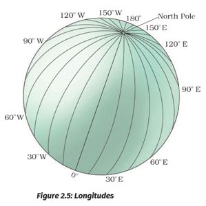
To fix the position of a place, it is necessary to know something more than the latitude of that place. You can see, for example, that Tonga Islands (in the Pacific Ocean) and Mauritius Islands (in the Indian Ocean) are situated on the same latitude (i.e., 20° S). Now, in order to locate them precisely, we must find out how far east or west these places are from a given line of reference running from the North Pole to the South Pole. These lines of references are called the meridians of longitude, and the distances between them are measured in ‘degrees of longitude.’ Each degree is further divided into minutes, and minutes into seconds. They are semi-circles and the distance between them decreases steadily poleward until it becomes zero at the poles, where all the meridians meet.
-
PRIME MERIDIAN
PRIME MERIDIAN
Unlike parallels of latitude, all meridians are of equal length. Thus, it was difficult to number the meridians. Hence, all countries decided that the count should begin from the meridian which passed through Greenwich, where the British Royal Observatory is located. This meridian is called the Prime Meridian. Its value is 0° longitude and from it, we count 180° eastward as well as 180° westward. The Prime Meridian and 180° meridian divide the earth into two equal halves, the Eastern Hemisphere and the Western Hemisphere. Therefore, the longitude of a place is followed by the letter E for the east and W for the west. It is, however, interesting to note that 180° East and 180° West meridians are on the same line.
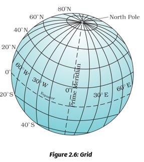
Now, look at the grid of the parallels of latitude and meridians of longitude on the globe (Figure 2.6). You can locate any point Now look at the grid of the parallels of latitude and meridians of longitude on the globe (Figure 2.6). You can locate any point on the globe very easily if you know its latitude and longitude. For example, Dhubri in Assam is situated at 26° N latitude and 90° E longitude. Find out the point where these two lines cut each other. That point will be the location of Dhubri.
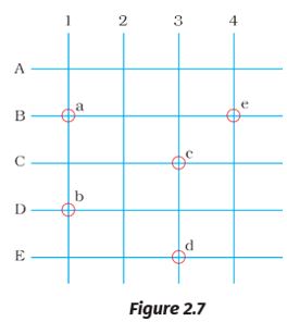
To understand this clearly draw equidistant vertical and horizontal lines on a paper (Figure 2.7). Label the vertical rows with numbers and horizontal rows with letters, draw some small circles randomly on points where these horizontal and vertical lines intersect each other. Name these small circles as a, b, c, d, and e.
Let vertical lines represent East Longitudes and horizontal lines as North Latitudes. Now you will see that circle ‘a’ is located on B° N latitude and 1° E longitude.
Find out the location of other circles.
Activity: Let’s Do
Draw a circle. Let the Prime meridian divide it into two equal halves. Colour and label the eastern hemisphere and the western hemisphere. Similarly, draw another circle and let the equator divide it into two halves. Now colour the Northern hemisphere and Southern hemisphere.
-
LONGITUDE AND TIME
LONGITUDE AND TIME
The best means of measuring time is by the movement of the earth, the moon, and the planets. The sun regularly rises and sets every day, and naturally, it is the best time-keeper throughout the world. Local time can be reckoned by the shadow cast by the sun, which is the shortest at noon and longest at sunrise and sunset.
When the Prime Meridian of Greenwich has the sun at the highest point in the sky, all the places along this meridian will have mid-day or noon.
As the earth rotates from west to east, those places east of Greenwich will be ahead of Greenwich time and those to the west will be behind it (Figure 2.8). The rate of difference can be calculated as follows. The earth rotates 360° in about 24 hours, which means 15° an hour or 1° in four minutes. Thus, when it is 12 noon at Greenwich, the time at 15° east of Greenwich will be 15 × 4 = 60 minutes, i.e., 1 hour ahead of Greenwich time, which means 1 p.m. But at 15° west of Greenwich, the time will be behind Greenwich time by one hour, i.e., it will be 11.00 a.m. Similarly, at 180°, it will be midnight when it is 12 noon at Greenwich.
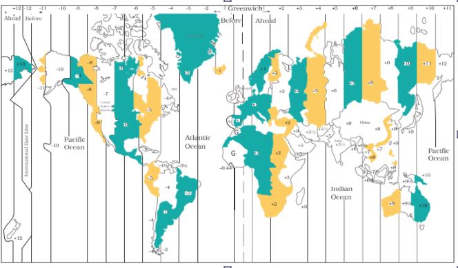
Figure 2.8: Time zones of the World
At any place, a watch can be adjusted to read at 12 o’clock when the sun is at the highest point in the sky, i.e., when it is mid-day. The time shown by such a watch will give the local time for that place. You can see that all the places on a given meridian of longitude have the same local time.
-
WHY DO WE HAVE STANDARD TIME?
WHY DO WE HAVE STANDARD TIME?
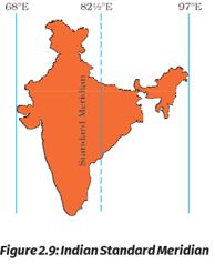
The local time of places which are on different meridians is bound to differ. For example, it will be difficult to prepare a time-table for trains which cross several longitudes. In India, for instance, there will be a difference of about 1 hour and 45 minutes in the local times of Dwarka in Gujarat and Dibrugarh in Assam. It is, therefore, necessary to adopt the local time of some central meridian of a country as the standard time for the country. In India, the longitude of 82½° E (82° 30'E) is treated as the standard meridian. The local time at this meridian is taken as the standard time for the whole country. It is known as the Indian Standard Time (IST).
Kabeer lives in a small town near Bhopal. He tells his friend Alok that they will not be able to sleep tonight. A day and night cricket match between India and England had started at 2 p.m. in London. This means that the match would begin at 7.30 p.m. in India and finish well into the night. Do you know what is the time difference between India and England?
India located east of Greenwich at 82°30'E is 5 hours and 30 minutes ahead of GMT. So it will be 7:30 p.m. in India when it is at 2:00 p.m. noon in London.
Some countries have a great longitudinal extent and so they have adopted more than one standard time. For example, in Russia, there are as many as eleven standard times. The earth has been divided into twenty-four time zones of one hour each. Each zone thus covers 15° of longitude.