-
POLITICAL AND ADMINISTRATIVE DIVISIONS
POLITICAL AND ADMINISTRATIVE DIVISIONS
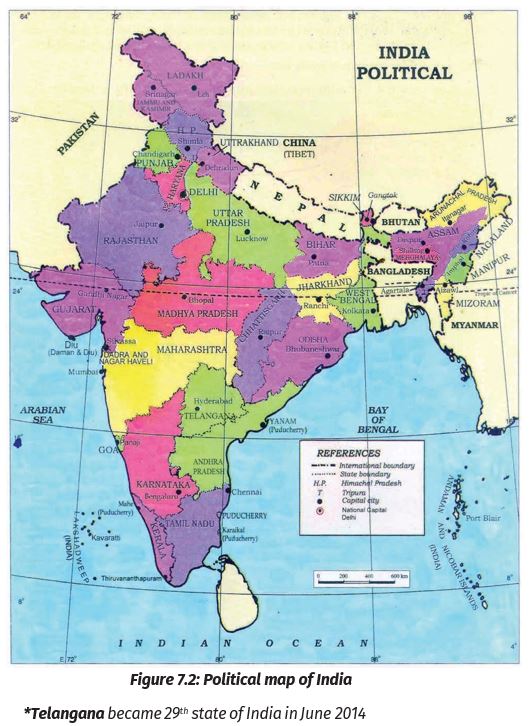
India is a vast country. For administrative purposes, the country is divided into 29 States and 9 Union Territories. Delhi is the national capital. The states have been formed mainly on the basis of languages.
S.No.
State
Capital
Union Territory
Capital
1
Andhra Pradesh
Hyderabad
Andaman & Nicobar Islands
Port Blair
2
Arunachal Pradesh
Itanagar
Chandigarh
Chandigarh
3
Assam
Dispur
Dadra & Nagar Haveli
Silvassa
4
Bihar
Patna
Daman & Diu
Daman
5
Chhattisgarh
Raipur
Lakshadweep
Kavaratti
6
Gujarat
Gandhi Nagar
Puducherry
Puducherry
7
Goa
Panaji
Delhi -National Capital Territory
Delhi
8
Haryana
Chandigarh
Jammu & Kashmir
Srinagar
9
Himachal Pradesh
Shimla
Ladakh
Leh
10
Jammu & Kashmir
Srinagar
11
Jharkhand
Ranchi
12
Karnataka
Bengaluru
13
Kerala
Thiruvananthapuram
14
Madhya Pradesh
Bhopal
15
Manipur
Imphal
16
Mizoram
Aizawl
17
Maharashtra
Mumbai
18
Meghalaya
Shillong
19
Nagaland
Kohima
20
Odisha
Bhubaneshwar
21
Punjab
Chandigarh
22
Rajasthan
Jaipur
23
Sikkim
Gangtok
24
Tamil Nadu
Chennai
25
Telangana
Hyderabad
26
Tripura
Agartala
27
Uttarakhand
Dehradun
28
Uttar Pradesh
Lucknow
29
West Bengal
Kolkata
Source: This Topic is taken from NCERT TEXTBOOK.
-
PHYSICAL DIVISIONS
PHYSICAL DIVISIONS
India is marked by a diversity of physical features such as mountains, plateaus, plains, coasts, and islands.
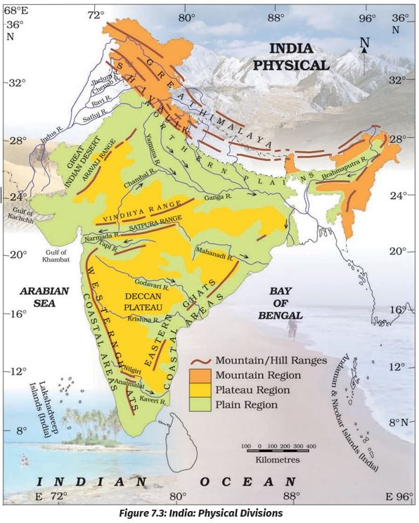
Standing as sentinels in the north are the lofty snow-capped Himalayas. Him+alaya means ‘the abode of snow’. The Himalayan mountains are divided into three main parallel ranges. The northernmost is the Great Himalaya or Himadri. The world’s highest peaks are located in this range. Middle Himalaya or Himachal lies to the south of Himadri. Many popular hill stations are situated here. Find out the names of five hill stations. The Shiwalik is the southernmost range.
The Northern Indian plains lie to the south of the Himalayas. They are generally level and flat. These are formed by the alluvial deposits laid down by the rivers– the Indus, the Ganga, the Brahmaputra, and their tributaries. These river plains provide fertile land for cultivation. That is the reason for the high concentration of the population in these plains.
In the western part of India lies the Great Indian desert. It is a dry, hot, and sandy stretch of land. It has very little vegetation.
To the south of the northern plains lies the Peninsular plateau. It is triangular in shape. The relief is highly uneven. This is a region with numerous hill ranges and valleys. Aravali hills, one of the oldest ranges of the world, border it on the north-west side. The Vindhyas and the Satpuras are the important ranges. The rivers Narmada and Tapi flow through these ranges. These are west-flowing rivers that drain into the Arabian Sea. The Western Ghats or Sahyadris border the plateau in the west and the Eastern Ghats provide the eastern boundary. While the Western Ghats are almost continuous, the Eastern Ghats are broken and uneven (Figure 7.3). The plateau is rich in minerals like coal and iron ore.
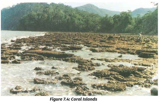
Corals are skeletons of tiny marine animals called Polyps. When the living polyps die, their skeletons are left. Other poplyps grow on top of the hard skeleton which grows higher and higher, thus forming the coral islands. Figure 7.4 shows the Coral islands.
To the West of the Western Ghats and the East of Eastern Ghats lie the Coastal plains. The western coastal plains are very narrow. The eastern Coastal plains are much broader. There are a number of east-flowing rivers. The rivers Mahanadi, Godavari, Krishna, and Kaveri drain into the Bay of Bengal. These rivers have formed fertile deltas at their mouth. The Sunderban Delta is formed where the Ganga and Brahmaputra flow into the Bay of Bengal.
Two groups of islands also form part of India. Lakshadweep Islands are located in the Arabian Sea. These are coral islands located off the coast of Kerala. The Andaman and the Nicobar Islands lie to the southeast of the Indian mainland in the Bay of Bengal. Tsunami is a huge sea wave generated due to an earthquake on the seafloor.
Do you know?
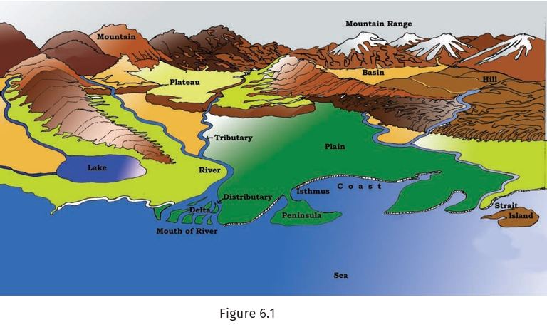
1. The Ganga and the Brahma- Putra forms the world’s largest delta, the Sundarbans delta. The delta is triangular in shape. It is an area of land formed at the mouth of the river (Where rivers enter the sea, that point is called the mouth of the river (Figure 6.1).
2. Alluvial deposits: These are very fine soils, brought by rivers and deposited in the river basins.
Tributary: A river or stream which contributes its water to the main river by discharging it into the main river from either side. (Figure 6.1).
Activity:
Let’s Do
1. Many girls are named after rivers eg. Yamuna, Mandakini, and Kaveri. Do you know anyone in your locality who is named after a river? Ask your parents and others and make a list of such names. Could you also find other names related to water e.g. Shabnam?
2. Do you know which group of islands were affected by the Tsunami in 2004? Find out through newspaper reports and by speaking to people how in different ways people faced this challenge when Tsunami struck the Indian coast.
Source: This Topic is taken from NCERT TEXTBOOK.