-
India - Location
LOCATION AND SIZE ( View Mind Map )
India is one of the ancient civilizations in the world. It has achieved multifaceted socio-economic progress during the last five decades. It has moved forward displaying remarkable progress in the field of agriculture, industry, technology, and overall economic development. India has also contributed significantly to the making of world history.
Location
India is a vast country. Lying entirely in the Northern hemisphere (Figure 1.1) the mainland extends between latitudes 8°4'N and 37°6'N and longitudes 68°7'E and 97°25'E.
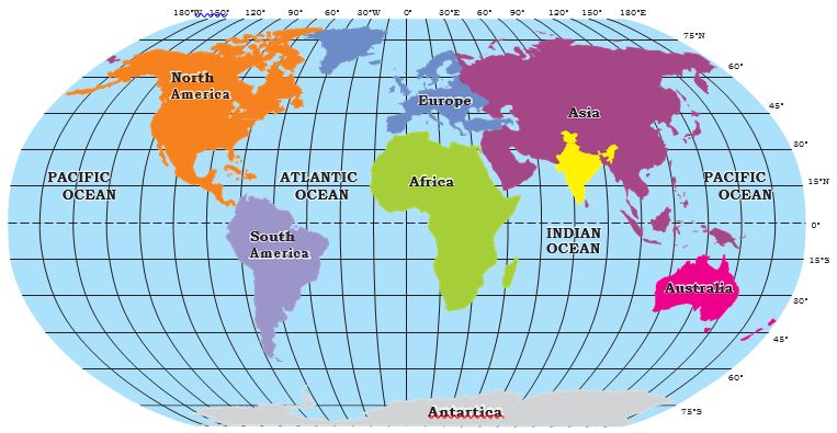
Figure 1.1: India in the World
The Tropic of Cancer (23° 30'N) divides the country into almost two equal parts. To the southeast and southwest of the mainland, lie the Andaman and Nicobar Islands and the Lakshadweep Islands in the Bay of Bengal and the Arabian Sea respectively. Find out the extent of these groups of islands from your atlas.
-
India - Size
Size
The landmass of India has an area of 3.28 million square km. India’s total area accounts for about 2.4 percent of the total geographical area of the world. From Figure 1.2 it is clear that India is the seventh-largest country in the world. India has a land boundary of about 15,200 km and the total length of the coastline of the mainland, including Andaman and Nicobar, and Lakshadweep is 7,516.6 km.
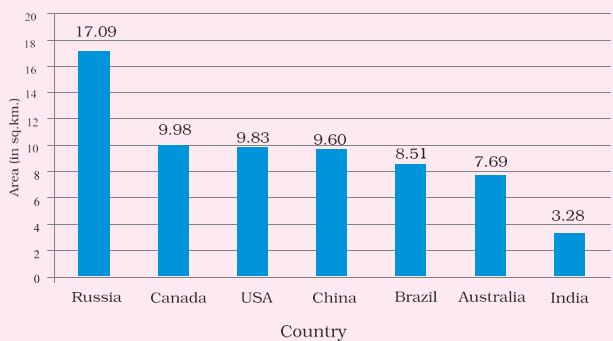
Figure 1.2: Seven Largest Countries of the World
India is bounded by the young fold mountains in the northwest, north, and northeast. South of about 22° north latitude, it begins to taper and extends towards the Indian Ocean, dividing it into two seas, the Arabian Sea on the west and the Bay of Bengal on its east.
-
India - Latitudes and Longitudes
Latitudes and Longitudes
Look at Figure 1.3 and note that the latitudinal and longitudinal extent of the mainland is about 30°. Despite this fact, the east-west extent appears to be smaller than the north-south extent.
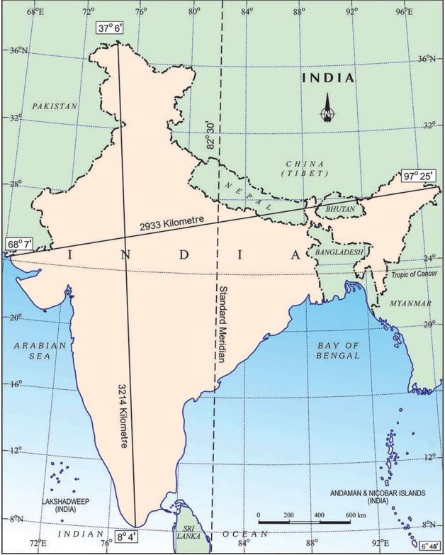
Figure 1.3: India: Extent and Standard Meridian
From Gujarat to Arunachal Pradesh, there is a time lag of two hours. Hence, time along the Standard Meridian of India (82°30'E) passing through Mirzapur (in Uttar Pradesh) is taken as the standard time for the whole country. The latitudinal extent influences the duration of day and night, as one moves from south to north.
More to know
The southernmost point of the Indian Union– ‘Indira Point’ got submerged under the seawater in 2004 during the Tsunami.
Let’s find out
* Why 82°30'E has been selected as the Standard Meridian of India?
* Why is the difference between the duration of day and night hardly felt at Kanniyakumari but not so in Kashmir?
-
India and The World
INDIA AND THE WORLD
The Indian landmass has a central location between East and West Asia. India is a southward extension of the Asian continent. The trans-Indian Ocean routes, which connect the countries of Europe in the West and the countries of East Asia, provide a strategic central location to India. Note that the Deccan Peninsula protrudes into the Indian Ocean, thus helping India to establish close contact with West Asia, Africa, and Europe from the western coast and with Southeast and East Asia from the eastern coast. No other country has a long coastline on the Indian Ocean as India has and indeed, it is India’s eminent position in the Indian Ocean, which justifies the naming of an Ocean after it.
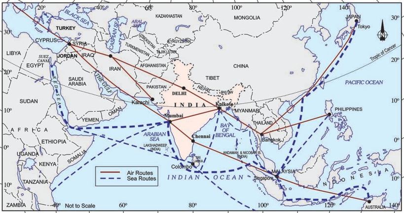
Figure 1.4: India on the International Highway of Trade and Commerce
India’s contacts with the World have continued through ages but her relationships through the land routes are much older than her maritime contacts. The various passes across the mountains in the north have provided passages to the ancient travelers, while the oceans restricted such interaction for a long time.
These routes have contributed to the exchange of ideas and commodities since ancient times. The ideas of the Upanishads and the Ramayana, the stories of Panchtantra, the Indian numerals, and the decimal system thus could reach many parts of the world. The spices, muslin, and other merchandise were taken from India to different countries. On the other hand, the influence of Greek sculpture, and the architectural styles of dome and minarets from West Asia can be seen in different parts of our country.
More to know
Since the opening of the Suez Canal in 1869, India’s distance from Europe has been reduced by 7,000 km.
Source: This topic is taken from NCERT TEXTBOOK