-
ROADWAYS
ROADWAYS
India has one of the largest road networks in the world, aggregating to about 56 lakh km. In India, roadways have preceded railways. They still have an edge over railways in view of the ease with which they can be built and maintained. The growing importance of road transport vis-à-vis rail transport is rooted in the following reasons;
(a) construction cost of roads is much lower than that of railway lines,
(b) roads can traverse comparatively more dissected and undulating topography,
(c) roads can negotiate higher gradients of slopes and as such can traverse mountains such as the Himalayas,
(d) road transport is economical in the transportation of a few persons and a relatively smaller amount of goods over short distances,
(e) it also provides door-to-door service, thus the cost of loading and unloading is much lower,
(f) road transport is also used as a feeder to other modes of transport such as they provide a link between railway stations, air, and seaports.
In India, roads are classified in the following six classes according to their capacity. Look at the map of the National Highways and find out about the significant role played by these roads.
Golden Quadrilateral Super Highways
The government has launched a major road development project linking Delhi-Kolkata-Chennai-Mumbai and Delhi by six-lane Super Highways. The North-South corridors linking Srinagar (Jammu & Kashmir) and Kanniyakumari (Tamil Nadu), and East-West Corridor connecting Silchar (Assam) and Porbander (Gujarat) are part of this project. The major objective of these Super Highways is to reduce the time and distance between the megacities of India. These highway projects are being implemented by the National Highway Authority of India (NHAI).
National Highways
National Highways link extreme parts of the country. These are the primary road systems and are laid and maintained by the Central Public Works Department (CPWD). A number of major National Highways run in North-South and East-West directions. The historical Sher-Shah Suri Marg is called National Highway No.1, between Delhi and Amritsar.
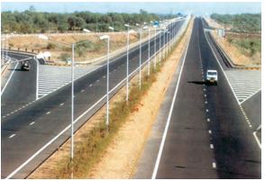
Figure 7.2: Ahmedabad- Vadodara Expressway
State Highways
Roads linking a state capital with different district headquarters are known as State Highways. These roads are constructed and maintained by the State Public Works Department (PWD) in State and Union Territories.
District Roads
These roads connect the district headquarters with other places of the district. These roads are maintained by the Zila Parishad.
Other Roads
Rural roads, which link rural areas and villages with towns, are classified under this category. These roads received special impetus under the Pradhan Mantri Grameen Sadak Yojana. Under this scheme, special provisions are made so that every village in the country is linked to a major town in the country by an all-season motorable road.
Border Roads
Apart from these, Border Roads Organisation a Government of India undertaking constructs and maintains roads in the bordering areas of the country. This organisation was established in 1960 for the development of the roads of strategic importance in the northern and north-eastern border areas. These roads have improved accessibility in areas of difficult terrain and have helped in the economic development of these areas.
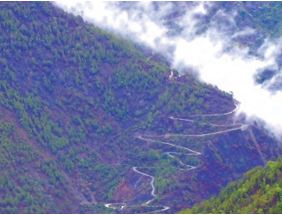
Figure 7.3: Hilly Tracts
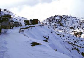
Figure 7.4: Traffic on north-eastern border road (Arunachal Pradesh)
Roads can also be classified on the basis of the type of material used for their construction such as metalled and unmetalled roads. Metalled roads may be made of cement, concrete or even bitumen of coal, therefore, these are all-weather roads. Unmetalled roads go out of use in the rainy season.
Activity:
Find out places linked by the National Highway 2 and 3.
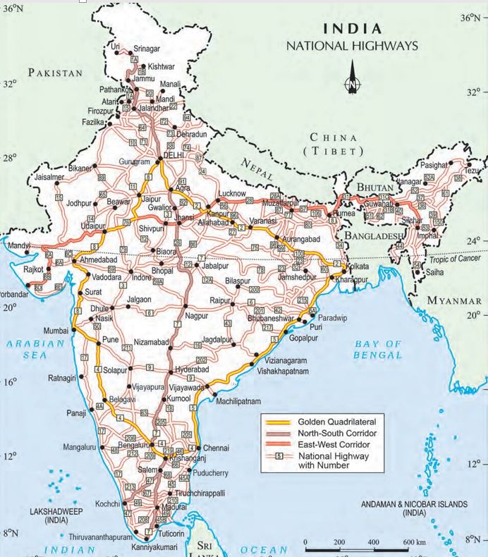
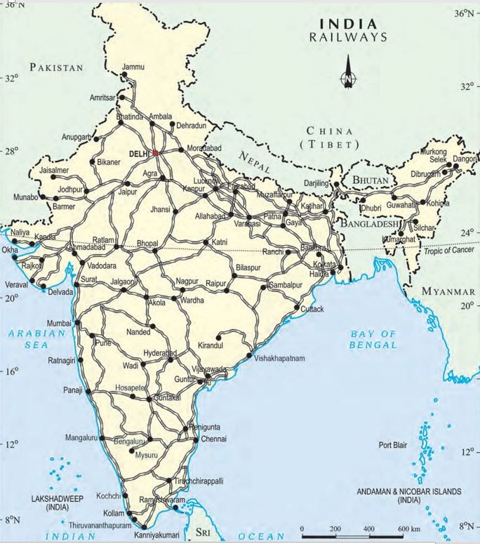
Figure: India: National Highways
Source: This topic is taken from NCERT TEXTBOOK
-
RAILWAYS
RAILWAYS
Railways are the principal mode of transportation for freight and passengers in India. Railways also make it possible for people to conduct multifarious activities like business, sightseeing, pilgrimage along with transportation of goods over longer distances. Apart from an important means of transport the Indian Railways have been a great integrating force for more than 150 years. Railways in India bind the economic life of the country as well as accelerate the development of the industry and agriculture.
The Indian Railway is now reorganised into 16 zones.
The distribution pattern of the Railway network in the country has been largely influenced by physiographic, economic, and administrative factors. The northern plains with their vast level land, high population density and rich agricultural resources provided the most favourable condition for their growth. However, a large number of rivers requiring construction of bridges across their wide beds posed some obstacles. In the hilly terrains of the peninsular region, railway tracts are laid through low hills, gaps or tunnels. The Himalayan mountainous regions too are unfavourable for the construction of railway lines due to high relief, sparse population, and lack of economic opportunities. Likewise, it was difficult to lay railway lines on the sandy plain of western Rajasthan, swamps of Gujarat, forested tracks of Madhya Pradesh, Chhattisgarh, Odisha, and Jharkhand. The contiguous stretch of Sahyadri could be crossed only through gaps or passes (Ghats). In recent times, the development of the Konkan railway along the west coast has facilitated the movement of passengers and goods in this most important economic region of India. It has also faced a number of problems such as the sinking of track in some stretches and landslides.
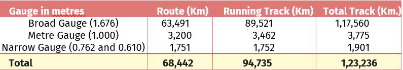
Table 7.1: India: Railway Track
(The Indian Railway network runs on multiple gauge operations extending over 68,442 km)
Today, the railways have become more important in our national economy than all other means of transport put together. However, rail transport suffers from certain problems as well. Many passengers travel without tickets. Thefts and damaging of railway property has not yet stopped completely. People stop the trains, pull the chain unnecessarily and this causes heavy damage to the railway. Think over it, how we can help our railway in running as per the scheduled time?
More to know
The Indian Railways is the largest public sector undertaking in the country. The first train steamed off from Mumbai to Thane in 1853, covering a distance of 34 km.
Activity :
1. Find out the current Railway zones and their headquarters. Also, locate the headquarters of Railway zones on the map of India.
2. Railway line has been extended from Banihal to Baramula in the Kashmir Valley. Locate these two towns on the map of India.
Source: This topic is taken from NCERT TEXTBOOK
-
PIPELINES
PIPELINES
Pipeline transport network is a new arrival on the transportation map of India. In the past, these were used to transport water to cities and industries. Now, these are used for transporting crude oil, petroleum products, and natural gas from oil and natural gas fields to refineries, fertilizer factories, and big thermal power plants. Solids can also be transported through a pipeline when converted into the slurry. The far inland locations of refineries like Barauni, Mathura, Panipat, and gas-based fertilizer plants could be thought of only because of pipelines. Initial cost of laying pipelines is high but subsequent running costs are minimal. It rules out trans-shipment losses or delays.
There are three important networks of pipeline transportation in the country.
* From oil field in upper Assam to Kanpur (Uttar Pradesh), via Guwahati, Barauni, and Allahabad. It has branches from Barauni to Haldia, via Rajbandh, Rajbandh to Maurigram, and Guwahati to Siliguri.
* From Salaya in Gujarat to Jalandhar in Punjab, via Viramgam, Mathura, Delhi, and Sonipat. It has branches to connect Koyali (near Vadodara, Gujarat) Chakshu, and other places.
* Gas pipeline from Hazira in Gujarat connects Jagdishpur in Uttar Pradesh, via Vijaipur in Madhya Pradesh. It has branches to Kota in Rajasthan, Shahajahanpur, Babrala, and other places in Uttar Pradesh.
Source: This topic is taken from NCERT TEXTBOOK
-
WATERWAYS
WATERWAYS
Since the ancient period, India was one of the seafaring countries. Its seamen sailed far and near, thus, carrying and spreading Indian commerce and culture. Waterways are the cheapest means of transport. They are most suitable for carrying heavy and bulky goods. It is a fuel-efficient and environment-friendly mode of transport. India has inland navigation waterways of 14,500 km in length. Out of these only 5685 km are navigable by mechanised vessels. The following waterways have been declared as the National Waterways by the Government.
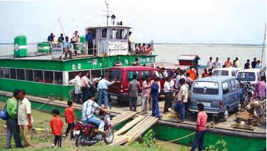
Figure 7.5: Inland waterways widely used in north-eastern states
* The Ganga river between Allahabad and Haldia (1620 km)-N.W. No.1
* The Brahmaputra river between Sadiya and Dhubri (891 km)-N.W. No.2
* The West-Coast Canal in Kerala (Kottapurma-Kollam, Udyogamandal and Champakkara canals-205 km) – N.W. No.3
* Specified stretches of Godavari and Krishna rivers along with Kakinada Puducherry stretch of canals (1078 km) – N.W. No.4
* Specified stretches of river Brahmani along with Matai river, delta channels of Mahanadi and Brahmani rivers and East Coast Canal (588 km) – N.W. No.5
There are some other inland waterways on which substantial transportation takes place. These are Mandavi, Zuari and Cumberjua, Sunderbans, Barak and backwaters of Kerala.
Apart from these, India's trade with foreign countries is carried from the ports located along the coast. 95 percent of the country’s trade volume (68 percent in terms of value) is moved by sea.
Major Sea Ports
With a long coastline of 7,516.6 km, India is dotted with 12 major and 200 notified non-majors (minor/intermediate) ports. These major ports handle 95 percent of India’s foreign trade.
Kandla in Kuchchh was the first port developed soon after Independence to ease the volume of trade on the Mumbai port, in the wake of the loss of Karachi port to Pakistan after the Partition. Kandla also is known as the Deendayal Port, is a tidal port. It caters to the convenient handling of exports and imports of highly productive granary and industrial belt stretching across the states of Jammu and Kashmir, Himachal Pradesh, Punjab, Haryana, Rajasthan and Gujarat.
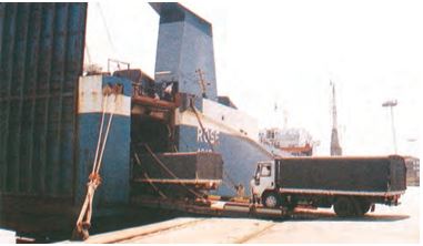
Figure 7.6: Trucks being driven into the vessel at Mumbai port
Mumbai is the biggest port with a spacious natural and well-sheltered harbour. The Jawaharlal Nehru port was planned with a view to decongest the Mumbai port and serve as a hub port for this region. Marmagao port (Goa) is the premier iron ore exporting port of the country. This port accounts for about fifty percent of India’s iron ore export. New Mangalore port, located in Karnataka caters to the export of iron ore concentrates from Kudremukh mines. Kochchi is the extreme south-western port, located at the entrance of a lagoon with a natural harbour.
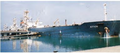
Figure 7.7: Tanker discharging crude oil at New Mangalore port
Moving along the east coast, you would see the extreme south-eastern port of Tuticorin, in Tamil Nadu. This port has a natural harbour and rich hinterland. Thus, it has a flourishing trade handling of a large variety of cargoes to even our neighbouring countries like Sri Lanka, Maldives, etc. and the coastal regions of India. Chennai is one of the oldest artificial ports of the country. It is ranked next to Mumbai in terms of the volume of trade and cargo. Vishakhapatnam is the deepest landlocked and well-protected port. This port was, originally, conceived as an outlet for iron ore exports. Paradwip port located in Odisha specialises in the export of iron ore. Kolkata is an inland riverine port. This port serves a very large and rich hinterland of the Ganga-Brahmaputra basin. Being a tidal port, it requires constant dredging of Hoogly. Haldia port was developed as a subsidiary port, in order to relieve growing pressure on the Kolkata port.
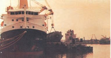
Figure 7.8: Handling of oversize cargo at Tuticorin port
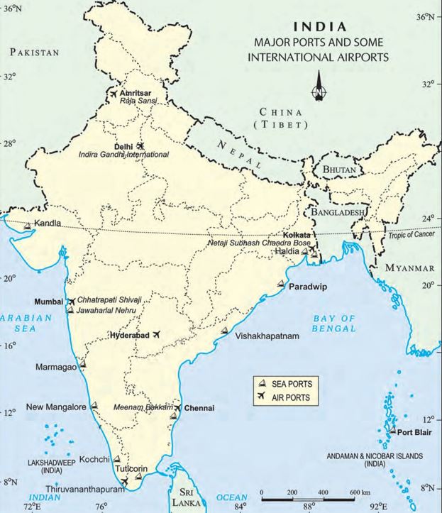
Figure : India: Major Ports and Some International Airport
Source: This topic is taken from NCERT TEXTBOOK
-
AIRWAYS
AIRWAYS
Air travel, today, is the fastest, most comfortable and prestigious mode of transport. It can cover very difficult terrains like high mountains, dreary deserts, dense forests and also long oceanic stretches with great ease. Think of the north-eastern part of the country, marked with the presence of big rivers, dissected relief, dense forests and frequent floods and international frontiers, etc. in the absence of air transport. Air travel has made access easier.
Air transport was nationalised in 1953. Air India provides domestic and international air services. Pawanhans Helicopters Ltd. provides helicopter services to Oil and Natural Gas Corporation in its off-shore operations, to inaccessible areas and difficult terrains like the north-eastern states and the interior parts of Jammu and Kashmir, Himachal Pradesh and Uttarakhand.
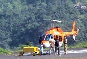
Figure 7.9:
Air travel is not within the reach of the common people. It is only in the north-eastern states that special provisions are made to extend the services to the common people.
Figure : India: Major Ports and Some International Airport
Activity:
1. Why is air travel preferred in the northeastern states?
2. Find out the names of the countries connected by Air India.
Source: This topic is taken from NCERT TEXTBOOK