-
Coastal Area and Islands
Cosatal areas and Islands
IntroductionThe Deccan plateau is flanked by coastal plains on the east and the west. Western coastal plains are washed by the Arabian Sea, whereas the eastern coastal plains are wetted by the Bay of Bengal. Both the plains meet at Kanyakumari, which is the southernmost tip of India
Western coastal plains are steeper and narrower than eastern coastal plains. Estuaries are formed by rivers on the western coast, while there are deltas on the eastern coast. The western coastline is largely straight, supported by continuous mountain ranges of the Western Ghats. As a result, it receives heavy rainfall from southwest monsoon. On the other hand, the eastern coastline is bent at an angle, and is crooked. The hills on its western sides are shorter and broken. Therefore, the eastern coast does not receive much rainfall from southwest monsoon.
-
Coastal Area and Islands
Western coastal plain
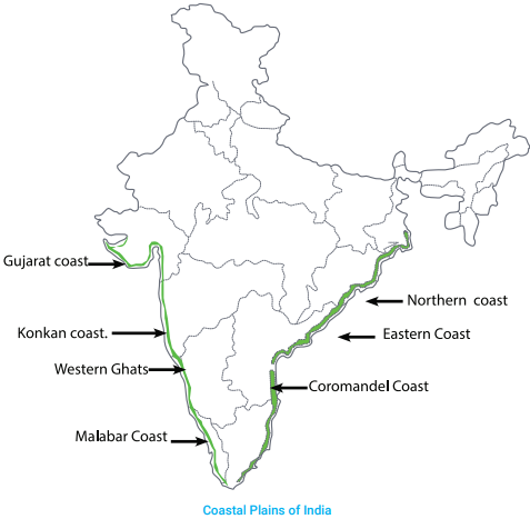
The western coastal plain stretches from the Gulf of Kutch in the north, to Kanyakumari in the south. Different parts of the coast are known by different names.
1. Gulf of Kutch to Gulf of Cambay is called Gujarat coast.
2. Gulf of Cambay to Goa is called Konkan coast.
3. Goa to Kanyakumari is called Malabar coast
1. Gujarat Coast
The Gujarat Coast is located along the Arabian Sea in the state of Gujarat The Rann of Kutch and the Gulf of Khambat are located in this plain. This region includes the Gir Forest which is home to the Asiatic lion.
2. Konkan Coast
The Konkan Coast extends from Gujarat to Goa. These plains are narrow and rocky. Some rocks run right into the ocean, which are dangerous because ships can run aground. To safeguard ships from these underwater rocks, many lighthouses have been built here. Mumbai is located on this coast.
3. Malabar Coast
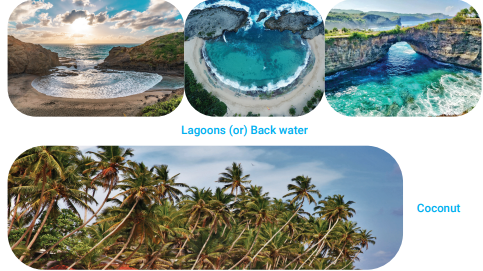
The Malabar Coast is located in the state of Kerala. These plains have been formed by the sand brought by the sea tides, so there are small sand-hills. This sand has formed a number of lagoons (or) Back water. These lagoons are used for navigation by boats. This region is well-known for boat races on the occasion of Onam. It rains much, so this area is green and fertile. The important crops here include banana, rice, coconut, coffee etc.
-
Coastal Area and Islands
Western coastal plain
The western coastal plain stretches from the Gulf of Kutch in the north, to Kanyakumari in the south. Different parts of the coast are known by different names.
1. Gulf of Kutch to Gulf of Cambay is called Gujarat coast.
2. Gulf of Cambay to Goa is called Konkan coast.
3. Goa to Kanyakumari is called Malabar coast
1. Gujarat Coast
The Gujarat Coast is located along the Arabian Sea in the state of Gujarat The Rann of Kutch and the Gulf of Khambat are located in this plain. This region includes the Gir Forest which is home to the Asiatic lion.
2. Konkan Coast
The Konkan Coast extends from Gujarat to Goa. These plains are narrow and rocky. Some rocks run right into the ocean, which are dangerous because ships can run aground. To safeguard ships from these underwater rocks, many lighthouses have been built here. Mumbai is located on this coast.
3. Malabar Coast
The Malabar Coast is located in the state of Kerala. These plains have been formed by the sand brought by the sea tides, so there are small sand-hills. This sand has formed a number of lagoons (or) Back water. These lagoons are used for navigation by boats. This region is well-known for boat races on the occasion of Onam. It rains much, so this area is green and fertile. The important crops here include banana, rice, coconut, coffee etc.
-
Coastal Area and Islands
Eastern Coastal Plains The eastern coastal plains lie between the Eastern Ghats and the Bay of Bengal and stretch from West Bengal to Kanyakumari. These plains can be divided into two parts.
1.Northern Circars :
The Northern Circars are located in coastal Odisha and Andhra Pradesh. The Mahanadi, the Godavari and the Krishna rivers make large deltas in this region. So, these plains are fertile and favourabale for the rice crop. The ocean is very deep, so a number of ports are located here. Vishakhapatnam is an important port which is used for ship-building also.
2.Coromandel Coast :
The Coromandel Coast comprises coastal plains. These are located between the Krishna and Kaveri rivers. These two rivers have formed fertile deltas here, which make it very suitable for the rice crop. Owing to abundant rice crop, this area is also called the rice bowl of India. The other important crops grown here include sugarcane, coconut, oilseeds and tobacco. These plains fall in the state of Tamil Nadu. Chennai is an important seaport in this coast. The Andaman and Nicobar group of islands is located in the deep Bay of Bengal about 1353 kilometres from Chennai. This group comprises 350 big and small islands. These islands are in the form of a cluster. The northern cluster forms Andaman and comprises 204 islands. The southern cluster is Nicobar which is made up of 19 islands. These two clusters together form the union territory of Andaman and Nicobar with the capital at Port Blair. 1. Andaman and Nicobar Group of Islands In addition to the mainland, India’s territory comprises a number of islands. An island is a piece of land surrounded by sea on all sides. We can divide these Indian islands into two groups : Andaman and Nicobar group of islands in the Bay of Bengal and Lakshadweep group of islands in the Arabian Sea
-
Coastal Area and Islands
1. Andaman and Nicobar Group of Islands
The Andaman and Nicobar group of islands is located in the deep Bay of Bengal about 1353 kilometres from Chennai. This group comprises 350 big and small islands. These islands are in the form of a cluster. The northern cluster forms Andaman and comprises 204 islands. The southern cluster is Nicobar which is made up of 19 islands. These two clusters together form the union territory of Andaman and Nicobar with the capital at Port Blair
Some of these islands are not inhabited. The southernmost point of India, Indira Point, is located in these islands.
The Barren Island, India’s only active volcano, is located in this group. Abundant rain in these islands has resulted in much greenery here. The weather is pleasant. So, tourism has become the chief industry in these islands. Fishing is an important occupation.
2. Lakshadweep Group of Islands
Located about 972 kilometres from Mumbai, Lakshadweep is a group of 27 islands in the Arabian Sea. These islands are formed from coral deposits and are hardly 4 to 5 metres above the sea level. All these islands are small and flat. 17 of these islands are not inhabited. These islands together form the union territory of Lakshadweep with the capital at Kavaratti. The weather is pleasant and the chief occupation of people is fishing.