-
The Northern Plains
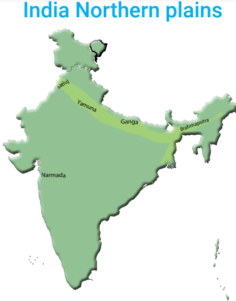
Northern Plains
IntroductionA plain is a large flat area of fertile land. A large part of Northern India makes up the Northern Plains. This region is plain and flat and extends from Punjab in the west to Assam in the east.
located between south of the Himalayas and north of the Peninsular plateau. formed by the deposition of the sediments brought by three main river systems namely : the Indus, the Ganga and the Brahmaputra.
2400 km long and its width varies from about 300 km in the west to about 150 km in the east. It mainly includes the states of Punjab, Haryana, Uttar Pradesh, Bihar, West Bengal and Assam. plain is one of the largest and most fertile plains of the world. Major crops such as wheat, rice, sugarcane, pulses, oil seeds and jute are grown here. Rivers that start from the snow clad Himalayas flow through these plains.
This deposit of fine silt ,clay and gravel is called alluvium which is extremely fertile and ideal for growing crops. These rivers divide it into three river basins ( a basin is a region drained by a river and its tributaries.
1. satluj River
2.The Ganga River
3. The Brahmaputra River The western part of the northern plain is referred to as the Punjab plain.
The Indus and its tributaries — the Jhelum, the Chenab, the Ravi, the Beas and the Satluj originate in the Himalaya. This section of the plain is dominated by the doabs. The Bhakra Nangal Dam built on river satluj is one of the largest dams of India. Wheat is the main crop in this basin
-
The Northern Plains
The Ganga River
It is drained by the rivers Yamuna, Ganga, Ghaghara, Gandak, Kosi and Teesta from the Himalayas in the north.
The river Ganga originates from the Gangotri glacier.
The rivers Bhagirathi, Mandakini and Alaknanda join the Ganga while it flows down the mountains. The river Ganga meets the river Yamuna at Prayagraj. On reaching West Bengal, the Ganga splits into two main branches- the Hooghly and the Padma. Hooghly flows through the city of Kolkata.
The river Padma flows through Bangladesh. Due to the deposition of silt, these rivers split into a number of channels known as Distributaries.
Triangular formation of small islands of sand in water are called the delta. Sunderbans is the largest delta in the world. People are engaged in agriculture
The Ganga Basin produces a large quantity of food crops like rice, wheat, sugarcane and jute, it is called the food bowl of India
-
The Northern Plains
Yamuna River
Yamuna is the sub-basin of the Ganga river system. It rises in the Yamunotri glacier and flows through the states of Haryana and Uttar Pradesh before joining the Ganga at Prayagraj. The Yamuna is a tributary of the Ganga, but it has its tributaries too, the important ones of which are the Chambal, the Sind, the Betwa and the Ken.
The Brahmaputra River
This basin lies in Assam.
The main river of this basin is Brahmaputra.
It originates in Tibet where it is called Tsangpo.
It enters India through Arunachal Pradesh.
This basin gets the highest rainfall in the world.
The main crops are rice and jute.
Tea is grown on the hill slopes.
-
The Northern Plains
Importance of Northern plains
The area is also rich in ground water sources.
Its soils have the capacity to grow any crop of the tropical and temperate regions.
They are the largest and most fertile plains of the world. Importance of Northern plains The northern plains are located to the south of the northern mountains.
The plains have been formed by the rivers originating in the Himalayas.
The plains are fertile, so several crops can be grown here. The northern plains are chiefly formed by three rivers : the Indus, Ganga and Brah maputra, and their tributaries.
The Yamuna rises in the Himalayas and joins the Ganga at Sangam in Prayagraj.
The Brahmaputra is a swift river and often floods.
The northern plains can support a dense population.